Unit of Practice

WORLD TRAVEL EXCURSION

Students will be traveling to three foreign countries – starting and ending in their hometown.  The student will start by finding three countries on the map they would like to travel to.  Students must cross the equator at least once.  Each student will have to keep track of the expenses they will encounter on their three-week trip.  They will find facts about each country, its capital, the climate, places they plan to stay, and the different types of food they will be eating.   Students will use the library, Internet, and travel agencies to find the necessary information.  They will then create a power point presentation on the trip they will be taking, which will be presented to the class.

  Invitation

How can we get students interested in different cultures from around the world?  How can students use the Internet to gain knowledge about different countries?   How can students understand the different transportation systems throughout the world?  What can students do for activities when traveling to another country?

  Unit Details

  Subjects:  Social Studies, Language Arts

Learning Level:  High School, Middle School

Author(s):  Jeff Schlekeway

Submitted by:  Jeff Schlekeway

Situations

  Research for the social studies activities will be performed using reference materials in class, the library, and computers with Internet capability.  The products will be completed during social studies class individually.  Each country should be completed within one week.

  Language Arts activities will require the use of a computer for the processing of the power point presentation.  The library will also be u used to gather materials about each country.  The amount of time will be determined by the success of researching, writing, and refining the end products.

Tasks

Students will research three countries that they plan to visit on their trip and create a power point presentation that they will orally present to the class.  They will write an itinerary (timeline of activities planed) for a one-week stay in each country.  Students will provide factual information about each country.  The students will access the Internet and use the library to find information on the following:

  1. World Map (place stars on your destinations)
  2. Map of each country
  3. Longitude and latitude of each location
  4. Factual information about each location
  5. Tourists attractions
  6. Outdoor activities they will be able to do and see
  7. The transportation system (trains, cars, boats, ect.) they will be using during the trip.
  8. Pictures of each location
  9. The capital of each country
  10. The climate for the year
  11. Cities you visit in each country
  12. Cross the equator once

Interactions

Students will work by themselves throughout the project.  If more then one student is doing the same country, the teacher may choose to have the students work together to make one PowerPoint.

Students will visit a local travel agency to get information about different countries they may travel to.

Students will present their PowerPoint to the class and answer follow up questions from their fellow students and teacher.  
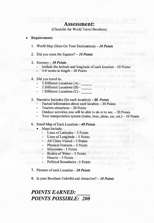
Assessment

Assessment tools will include written and oral presentation (power point).  Students will also be assessed by a rubric to make sure all the information includes all aspects in their project (see project section for assessment tool).

                                                                                            Rubric

                                   airport1.JPG (161213 bytes)                          
       Click to Enlarge

Tools

Computer on network with Internet access, an integrated software program such as Microsoft Office and software with appropriate peripherals.

Infocus Projector to project PowerPoint presentations and a large screen.

Library with a full compliment of resources including CD-ROMs, books on world cultures and encyclopedias.

Internet sources can include but are not limited to:

http://www.nationalgeographic.com/resources/ngo/maps/

http://www.britannica.com/

http://clever.net/cam/encyclopedia.html

URL

Http://teachers.k12.sd.us/js116